I started this blog at the urging of friends and family in April 2010 when my husband and I were given an opportunity to relocate in Maryland for one year. We have now returned home to Arizona and continue to walk by faith as we watch God orchestrate the adventures in our lives. I invite you to share in our adventures as we watch God at work!

We live by faith, not by sight. 2 Corinthians 5:7


Tuesday, October 23

four fun things

As we were touring the Lake Powell/Page area in north-central Arizona, we stumbled upon several lesser known, unique things in Arizona and visited one well-known one in Utah. They are definitely worth a look-see if you are ever in the area.

1. Hanging Gardens - Just north of Page on US-89 is a gravel turnoff on the right-hand side of the road. Follow the gravel road about 500 yards to the trailhead for Hanging Gardens where an easy, one-mile round-trip hike will take you to a lush oasis in the middle of an arid desert. Some 35 species of plants cling to the top and side of the moisture-dripping, spring-fed rock tucked inside an overhang. It was a welcome respite the afternoon we were there - a great place to sit a spell and think.

Hanging Garden Collage
The hike to the Hanging Gardens has some breath-taking panoramic views of Lake Powell and Glen Canyon in the distance!

2. Cliff Dwellings - In 1929, a Ziegfeld Follies dancer from back east named Blanche Russell was traveling through Marble Canyon north of the recently completed Navajo Bridge with her husband, Bill, who had recently been diagnosed with tuberculosis. They were moving to the southwest where they hoped the drier climate would be better for Bill's health. Their car broke down forcing them to "camp" overnight and in the light of the morning, Blanche decided that she liked the scenery and bought the property. They built a lean-to against one of the boulders that had broken off the cliff above and settled on soft sandstone which gradually eroded away underneath the boulder leaving crevices and odd-shaped formations. They served food to passers-by in exchange for labor to build their house with the boulder. This ultimately led to a full-fledged restaurant and a hand gasoline pump which meant more buildings, all completed in the early 1930's. The dwellings remain on private property (although visitors are welcome) and have been vacant for the last half century. It started raining while we were there so we sought shelter in one - and stayed relatively dry!

Rock Houses Collage
Remember the house that Practical Pig built? These would have been just as wolf-proof!

3. Balanced Boulders (or Balanced Rocks) - The giant boulder appears to have been placed perfectly balanced on its pedestal near Lees Ferry. In reality, a very long time ago the boulder of conglomerate rock broke off the cliffs high above and rolled down the slope until it stopped. The much softer rock it landed on has eroded away much more quickly than the conglomerate boulder forming a pedestal. The pedestal will continue to erode more quickly and one day the boulder will topple over again where the process will be repeated. Eventually weathering will break down the conglomerate boulder leaving a pile of rocks like others seen nearby. The same process is occurring along the top of the cliffs in the area; softer rock erodes away leaving precariously perched overhangs of harder rock that will someday break off and roll down the slope - a process called "cliff retreat."

Balanced Rock Collage
The surreal lanscape looks more like a sci-fi movie set than it does a natural process!

4. Rainbow Bridge - This magnificent natural wonder, the largest natural bridge in the world, is located in Utah on the Navajo Reservation and is a sacred site for five Native American nations. The bridge was formed by water flowing from Navajo Mountain to the Colorado River eroding the sandstone. It was "discovered" in 1909 by the Douglas-Cummings Surveyor party and in 1910, President Taft declared it a National Monument. At that time,  the only way to reach it was climbing/hiking several miles up Bridge Canyon from the bank of the Colorado River making it one of the most remote and inaccessible places in the country. In 1963, the gates on Glen Canyon Dam closed and the rising Lake Powell began to engulf the Colorado River and the side canyons with their rivers and streams. Soon Rainbow Bridge was accessible by boat with a very short, level hike and visitation to the monument exploded. Lawsuits were filed by Native American nations against the U.S. Department of the Interior but the courts ruled that closing Rainbow Bridge National Monument to the public for Navajo religious ceremonies would violate the U.S. Constitution which protects the religious freedoms of all Americans. Compromises were made restricting crowds as well as being respectful of the Native American beliefs. We took a two and a half hour boat ride maneuvering narrow channels in small canyons to get to the dock where we walked about a half mile to Rainbow Bridge. 

Rainbow Bridge Collage
Photos cannot do justice to this impressive formation - it is higher than the U.S. Capitol Building and nearly as long as a football field. The top of the arch is 42 feet thick and 33 feet wide! Having a person stand underneath it would give perspective but Navajo tradition forbids it.

While we left on our trip with a list and a plan, being spontaneous allowed us to see some really unusual sights (and sites!). It is becoming apparent to me that one could never see all there is to see in Arizona - or probably any state. And for the record, all four of these get a big THUMBS UP!

Monday, October 22

60/100... Northern Arizona, part 3 - WATER

The Arizona Strip. No, it's not a cut of meat like a New York Strip. It is 7,878 square miles north of the Colorado River in the north-western part of the state. This extremely rugged, very isolated section of the state is directly accessible to non-boat travelers in Arizona at just one crossing: Navajo Bridge near Lees Ferry (#60 on my "100 Things in Arizona" list) in the eastern part of the Strip. Cars can also cross the Colorado River on the Glen Canyon Bridge at Lake Powell and continue into Utah before crossing back into Arizona and into the Strip. There are quite a few gravel and dirt roads throughout the Arizona Strip that are only accessible from Utah or Nevada. In fact, some Arizonans living in the Arizona Strip must enter Utah or Nevada and then re-enter Arizona via the Glen Canyon Dam bridge or the Mike O'Callaghan/Pat Tillman Memorial Bridge (Lake Mead) to get anywhere in Arizona south of the Colorado River.

The Colorado River, with its headwaters in the Rocky Mountains in Colorado, is the principal river in the United States southwest supplying both water and electricity to millions of people in seven states. It enters Arizona via Lake Powell which lies on the Arizona - Utah state line. Glen Canyon Dam in Arizona creates Lake Powell as a water reservoir to ensure a constant supply of water as well as generate electricity for much of the western grid.

front and back of dam collage
Lake Powell on the north side of Glen Canyon Dam and the Colorado River on the south side. 

Tours of dams are always interesting to me and this one was no different. The structure itself is an engineering marvel. It is 300 feet thick at the base and just 25 feet thick at the crest which explains why it took over 4.9 million cubic yards of concrete to build it. Using water to generate electricity is pure genius - and the Glen Canyon power plant generates enough energy to supply 425,000 households with electricity for one year. I am a visual learner so seeing both how the dam was engineered and built as well as how the electricity is "made" helped me understand both. 

We took a very fast elevator inside the dam down to the bottom. As soon as we stepped off the elevator, the air was much, much cooler from the cold water at the bottom of the lake transferring its heat (or lack of!) through the concrete. We eventually walked out the front side of the dam to the power plant.

dam grass collage
View from the bottom and the top of the dam. The grass was planted to keep the dirt from blowing around - kind of looks like a golf course! Our guide told us some workers hit a few golf balls on it for stress relief! And yes, they use lake water to water it.

After walking around the lawn, we went inside the power plant. Our guide explained how the eight generators work.

electricity
They run as many generators as they need to for the electricity demand. This one was whirring so fast we couldn't see it move, it's just a blur.

Lake Powell is named after John Wesley Powell, the one-armed Civil War veteran who charted the Colorado River through Arizona in a wooden boat. This man-made lake (reservoir) is made by the Glen Canyon Dam backing up the water in the Colorado River and its tributaries (the San Juan River, for example). The dam was completed in 1963 but it wasn't until 1980 that it was "filled!" And only about a fifth of the lake lies in Arizona; the rest is in Utah.

Besides being a "water storage container" to help manage our water supply and a means of generating electricity, it is also a major recreational area attracting more than three million visitors annually. Sandstone canyons, beautiful beaches, thousands of miles of shoreline and warm water make it a destination for house-boaters, speed-boaters and everything in-between.

lake collage
We drove around the southern tip of the lake and it was pretty but its true beauty is revealed when you're on the lake!

Boaters can use Lake Powell to "cross the Colorado River" in Arizona but what do land vehicles use? Glen Canyon Bridge was completed in 1959 to carry building materials for the dam across the river. It is a continuation of US-89 which pushes on for a couple of miles before crossing into Utah.

Glen Canyon Dam Bridge
Glen Canyon Bridge is 700 feet above the river and at the time of its completion, was the highest arch bridge in the world. You can see how the high walls of Glen Canyon and the wide expanse of the Colorado River create an almost impenetrable barrier.

Arizona separated from the New Mexico Territory and became its own US territory in 1863. At that time, there was NO WAY to cross the Colorado River leaving the area north of the river (now called the Arizona Strip) cut off from the rest of the territory. Residents often knew more about what was going on in Utah or Nevada than they did their own territory. 

The area was heavily settled by the Mormon Church which quickly realized that a reliable river crossing would help their expansion into the rest of the Arizona Territory. They sent men, supplies and a ferry operator named John D. Lee to a remote outpost where the Paria River flows into the Colorado River; where there is a brief interruption in the canyon walls separating Glen Canyon from Marble Canyon. It is the only place within hundreds of miles on either side that the canyon walls are mildly sloping rather than violently sheer enabling livestock and wagons to make it to the edge of the river.

Upstream from Lee's Ferry
The canyon is noticeably different at the confluence of the two rivers.

By 1873, a ferry operated by John D. Lee was established to cross the Colorado River. It became known as Lees Ferry (#42). A wooden barge-like boat capable of carrying one wagon and team would be loaded and then pulled upstream by men pulling on ropes. The boat was then pushed off from one side of the river (usually the north side) and the current would carry it downstream to the opposite shore. After off-loading the cargo, the ferry would again be pulled by ropes upstream where it would make the return trip to the starting shore. It took a lot of man-power and time to move a group of wagons, livestock and people across the river. And it was not without danger - the river was unpredictable in depth and speed and cargo, people and even the ferry itself were sometimes swept downstream never to be seen again. Once travelers got to the south side, they still needed to make a long, steep, uneven climb out of the canyon. It was not a trip for sissies! Despite the danger and hardship, large expeditions did proceed with the trek making the years from 1876 to 1890 the most active for the ferry operation.

Lee's Ferry 2
The place known as Lees Ferry is still used today as the launch site for river runners through the Grand Canyon.

The remote outpost became a little boom town before it became a ghost town, particularly once gold was discovered in the cliffs. Unfortunately, the gold was a fine powdery dust that couldn't be extracted so no one struck it rich.

Lee's Ferry buildings collage
Left: Building used as HQ for a gold mining company (1911) and later as a US Post Office (1922)
Middle: Plaque commemorating Lees Ferry
Right: Lees Ferry Fort built in 1874 by the Mormon Church

The ferry continued to operate into the 1920's. Improvements were made including attaching the ferry to a permanent track cable which would make crossing the river easier and safer. Its final trip was on June 7, 1928 when the boat twisted and capsized while carrying a Model T and two men across the river. All aboard drowned. 

By the 1920's pioneer wagon trains were replaced by automobiles carrying tourists and it became apparent that a different crossing was needed. Plans were made to build a bridge several miles downstream from Lees Ferry and construction began in 1927. Since the bridge was almost completed when the ferry capsized, it was decided not to rebuild the ferry but to wait for the bridge to be completed.

Navajo Bridge (#42) on US-89A was completed in 1929 and dedicated on June 15th of that year. At the time, it was an impressive steel arch bridge 467 feet up from the canyon floor. It was 834 feet long and had a load capacity of 22.5 tons. 

Old Navajo Bridge

But the really impressive part is that 7,000 people and 1,217 automobiles came to witness the historic event. You see, in 1929 the Panama Canal was open, the Titanic had sunk, and the first trans-Atlantic flight had taken place. But prior to the bridge being built, the ONLY way to cross the Colorado River in Arizona was an antiquated, unreliable ferry system. The bridge was a very big deal. For the first time people could safely and easily travel to the northwest part of the state, to the north rim of the Grand Canyon, for example.

The Navajo Bridge was heavily traveled for over half a century before it was decided in 1990 that the bridge was inadequate for traffic demands. Replacing the bridge was the only way to widen it to increase flow and bring it up to federal highway standards. The new bridge, looking visually similar, would be built next to the old one. The old bridge is now an equestrian/pedestrian bridge.

RAP at new Navajo Bridge
The new bridge opened in September, 1995. It is 75 feet longer, 3 feet taller and 26 feet wider than the old bridge.

There is a nice interpretive center and viewing areas between the two bridges. As we were viewing the canyon, the bridges and the cliffs in the background, we caught sight of a couple of California condors flying in the thermals and then resting on the cliff tops. They are such majestic-looking birds! California condors were facing extinction when The Peregrine Fund stepped in and began hatching chicks at their World Center for Birds of Prey in Boise, Idaho. The birds are then released to the wild in Arizona. Captive-bred California condors were released for the first time near the Grand Canyon in 1996; those condors are now raising their own wild chicks and foraging north into Utah.

condor collage
Though they are dwarfed by the cliff, these birds have the largest wingspan (9.8 feet!) of any North American bird and can weigh up to 26 pounds!

The Arizona Strip - that primitive, rugged section of our state cut off from the rest of the state by the unpredictable, wild Colorado River and the deep canyons it cut - has a fascinating history. I can't wait to see what the future holds for it!

Thumb Up or Down: UP for all!!
Miles Round Trip: 887.6 miles
Miles To Date: 9248.3 miles
Percent of List Completed: 83%
Date of This Trip: August 30 - September 3, 2012

Monday, October 15

18 and 53/100... Northern Arizona, part 2 - CANYONS

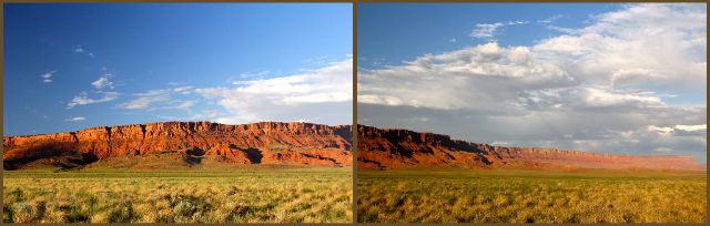
The Grand Canyon is the most visited place in Arizona attracting tourists from all over the world as well as the United States. And while it is a most awe-inspiring geological formation (aka "a hole in the ground") and will be a blog post for another day, I think most Americans are missing equally unique, breath-takingly beautiful canyons just 120 miles from the Grand Canyon. On our recent trip to northern Arizona, we visited three of them: Antelope Canyon (#8 on my "100 Things to Do in Arizona" list), Secret Canyon (not on my list but should have been!), and Glen Canyon at Horseshoe Bend Overlook (#53).

Canyons are formed when water erodes rock. Often a river will cut through rock forming a wide, deep canyon - like the Grand Canyon or Glen Canyon. Sometimes, though, it is rain that creates a canyon... like slot canyons in the desert of the southwestern US.

A cloudburst on the hard, dry desert plateaus doesn't soak into the ground, it runs off finding a gully or wash and then rushes downstream creating a wall of water. This is a flash flood. When the gully narrows, the turbulent wall of water pushes through a small crack in the rock quickly eroding it and then swirls through forming a narrow canyon. The next flash flood erodes more and the one after that even more until the floor of the canyon reaches much harder rock. Interestingly, the opening at the top of the slot canyon might be only a foot or two wide but the floor could be five or six feet (or more) wide.

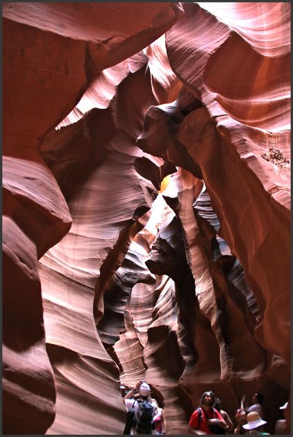
Antelope Canyon (#18) on the Navajo Reservation is perhaps the most well-known slot canyon in the United States. Because it is on tribal land, you must have a Navajo guide to tour it. Fortunately, there are about a dozen tour companies willing to accommodate tourists so finding one wasn't difficult. After loading 16-18 people on each of five trucks, our tour group drove about 10 miles from downtown Page to the entrance of Upper Antelope Canyon where our driver/tour guide walked us through the canyon.

Antelope Canyon - Navajo Tapestry
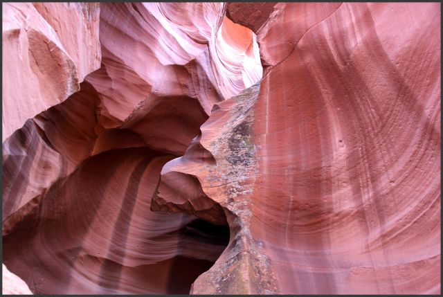
The dark vertical streaks on the canyon walls are called "Navajo Tapestry" (also called "desert varnish" off the reservation!) and are formed when iron oxide and other minerals collect on the rock.

The day we were at Antelope Canyon, there were about 200 - 250 people sharing the adventure with us. One guide said the most people he had ever seen in the canyon at one time was about 1200! It was a bit noisy at times and difficult to get photos with so many people walking around.

Antelope Canyon- people
Every person was awed by the uniqueness of this canyon.

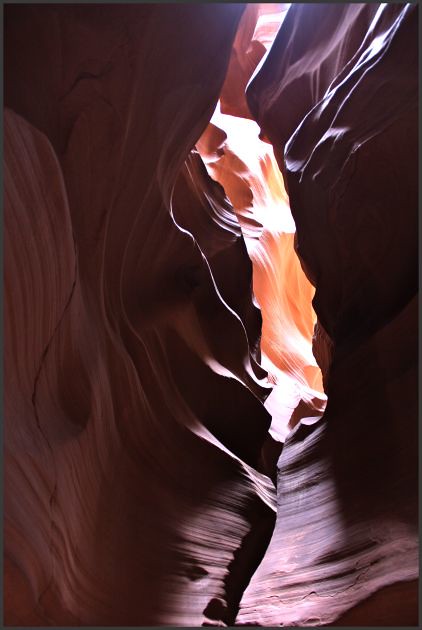
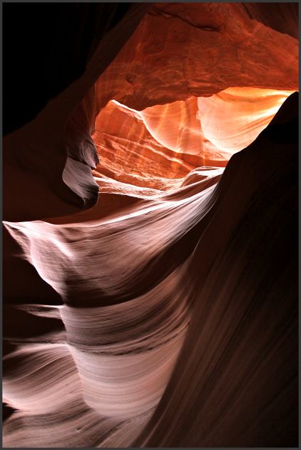
Even with a crowd, the beauty of the canyon is breath-taking. The colors change dramatically as the light shifts.

Antelope Canyon - #2
This shot was taken looking up. The walls of the canyon are 120 - 150 feet high. I felt quite dwarfed looking up!

Once we reached the end, which goes back outside, we turned around and walked back through the canyon. I was both amused and annoyed that the same "rule" for moving walkways everywhere applied to this natural wonder: stand on the right, walk on the left (of your half of the walk space)!

Antelope Canyon -#3
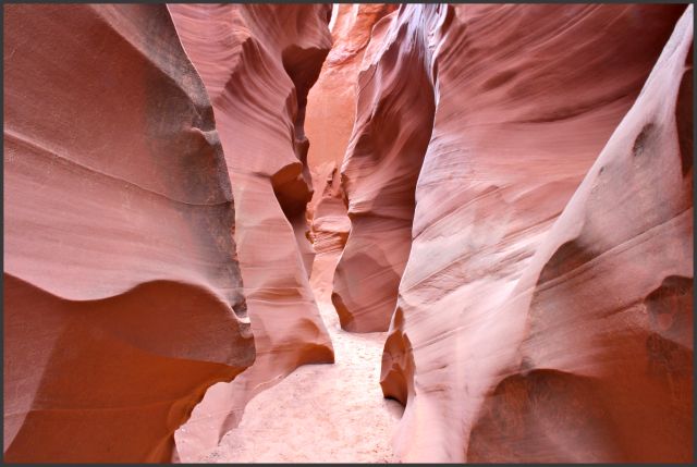
You can see the narrow confines of the canyon - it is definitely NOT for the claustrophobic! The floor is relatively level and flat but the walls twist and turn.

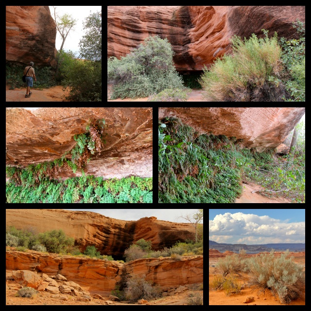
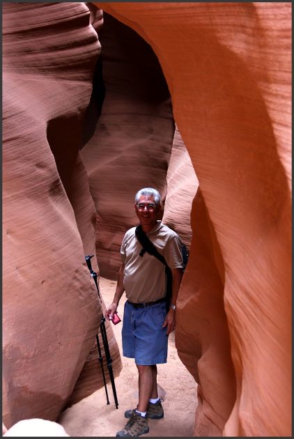
Without a doubt, Antelope Canyon is beautiful - but it is a little crowded for my taste. I was glad I had booked a tour for a different slot canyon (not on my list) with another tour company as my back-up in case it rained on the day of our Antelope Canyon tour. The experience was totally different! Our tour group was small - five people plus our guide, Matt. We traveled about 20 miles in a fully loaded Hummer to our destination: Secret Canyon.

Secret Canyon entrance
The entrance looks like an open hallway. We walked about a quarter of a mile through this terrain.

As we walked, Matt described how slot canyons are formed and explained that in "canyon age," slot canyons are young. They form relatively quickly because of the kind of sandstone - Navajo sandstone, which is essentially petrified sand dunes.

Secret Canyon #1
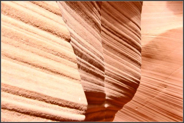
The layers of sandstone are easily seen.

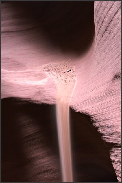
As flash floods rush through the canyon, they deposit debris picked up miles away as well as pick up additional debris in the canyon. Matt showed us a video (don't you just love smart phones?!) he took from high ground several weeks before our visit of a powerful flash flood that moved huge boulders!

Secret Canyon debris
This debris was deposited during that flash flood.

As we walked through the canyon, we could hear the quiet. Although it was a warm day, it was quite comfortable inside the canyon. It is a place to experience with all your senses. 

Secret Canyon #3
~ solitude ~

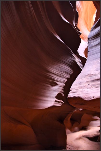
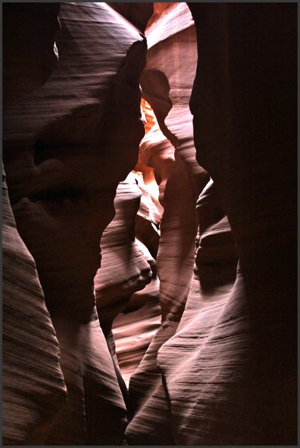
The texture of the canyon walls was intersting. Some places were smooth as glass; others were grainy. 

Secret Canyon texture
This wall reminded me of light and dark brown sugar. The opposite wall was quite smooth.

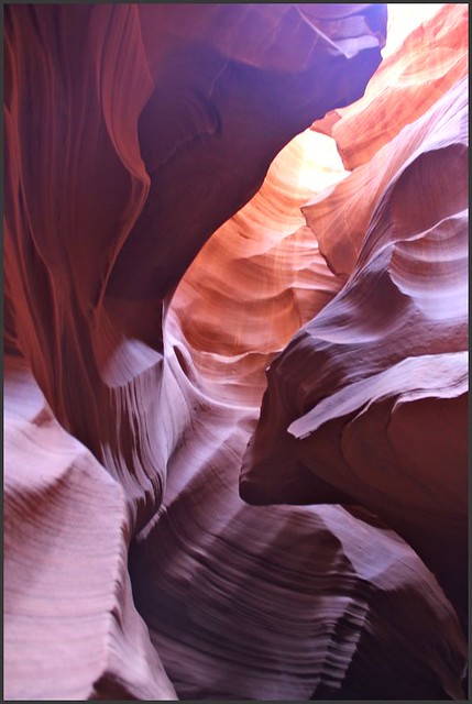
The rushing water sculpted the canyon walls with smooth brush swipes. 

Secret Canyon #4
Colors of amethyst, rose, peach and ochre fade one into the other creating a masterpiece. 

Matt gathered us into a small "room" to show us a sandfall. He placed a small handfull of sand on a ledge and gave it a gentle nudge over the side. Beautiful to watch!

Secret Canyon- sandfall

At times, even though I was standing perfectly still and there was not a drop of water in sight, I could feel the speed and turbulence of the whooshing water racing through the canyon much the same way that the pouncing cat-like curves on old race cars exuded speed just standing still.

Secret Canyon #6
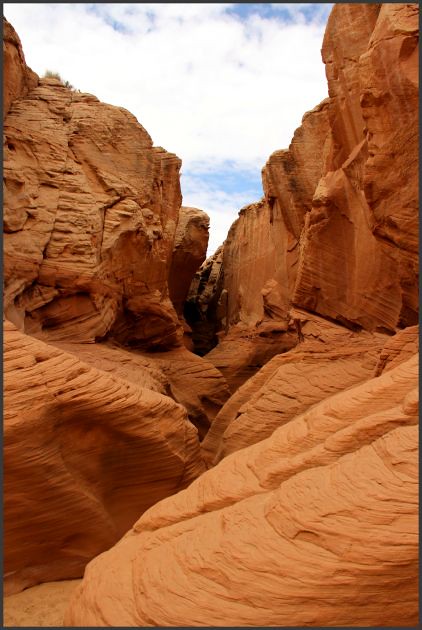
The rounded bowl areas are formed by whirlpools during violent flash floods.

This slot canyon was narrower than Antelope Canyon. Some places we had to slide by sideways. The floor, while mostly level, was not as flat as Antelope Canyon. In fact, there were a few places we had to climb over some rocks. Matt said Secret Canyon was not as old as Antelope Canyon and the bottom (that hard layer of rock) wasn't yet established.

Secret Canyon - Richard
Richard sometimes thinks he's the pack mule ;-)

Secret Canyon- "gears"
This formation, called "clock gears," is exquisite and quite narrow.

Each twist and turn  revealed something new to look at. All of a sudden, we turned a corner and the air felt warmer and the "back door" was open. 

Secret Canyon- back door
Secret Canyon's back door - which is really a misnomer since the rushing water enters here.

We walked back through the canyon the same way we came. The angles, colors, lighting and shadows are entirely different looking "backwards" so it was like a brand new canyon. 

Matt wanted to be sure we had a real "Hummer adventure" on the way back so we climbed rocks and at times I'd swear we were on two wheels. It was a fun adventure we'd never be able to do in a car.

Secret Canyon- clouds
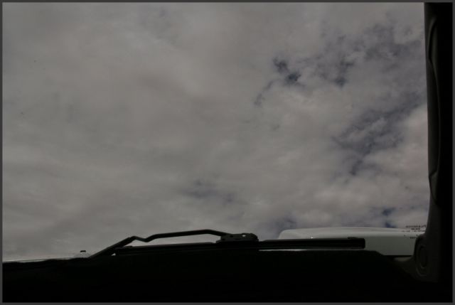
There is something wrong about looking out the windshield and seeing clouds high up in the sky!

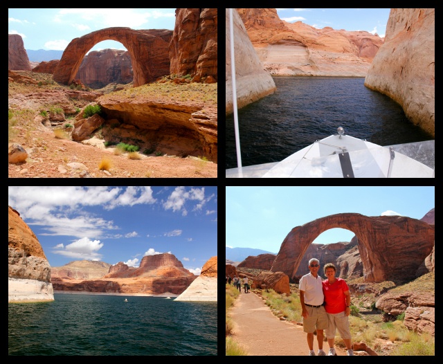
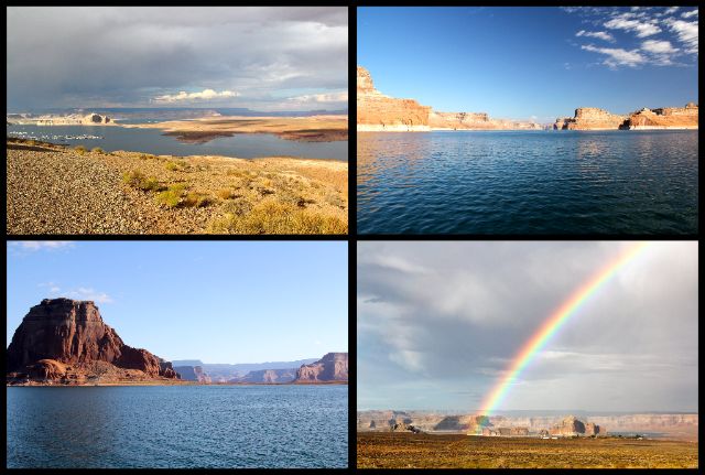
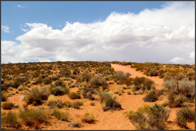
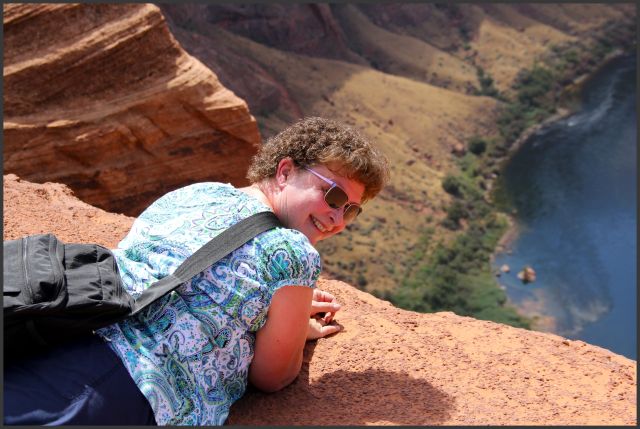
The third canyon we explored was Glen Canyon. We hiked to Horseshoe Bend Overlook (#53) to get an aerial view of the canyon. 

HB - trailhead
The sandy path on the right is the trail - six inches of very fine, very soft sand. It's like trying to walk through quicksand - or at least what I imagine walking through quicksand is like!

As I was dragging myself up the hill, I consoled myself with the thought that once I reached the top, I would be able to see the canyon. However...

HB - sandy trail
... once we reached the top of the hill, the sandy path continued for another third of a mile, now downhill - which, of course, would be uphill on the return trip. 

The downhill trek was a little easier as the path zig-zagged down to the edge of the canyon. The closer we got to the edge, the more Navajo sandstone we saw and eventually the fine sand gave way to the sandstone. As we approached the edge, we could see people at the overlook.


HB - people on edge
Surely there must be a guardrail or something at the edge!

HB - laying down
BUT THERE ISN'T!! 
Our guide at Secret Canyon had advised us to lay down and inch to the edge, not stand near the edge. He said people die every year falling off the edge.

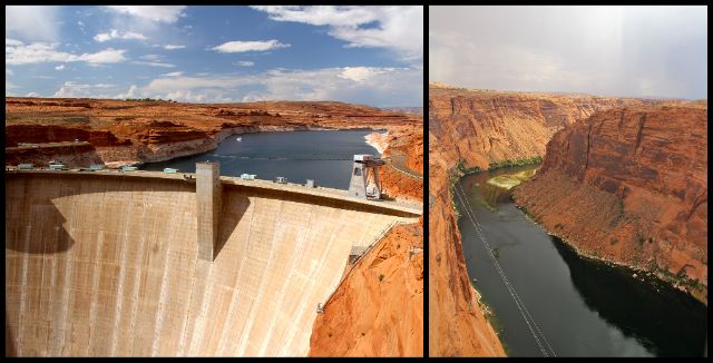
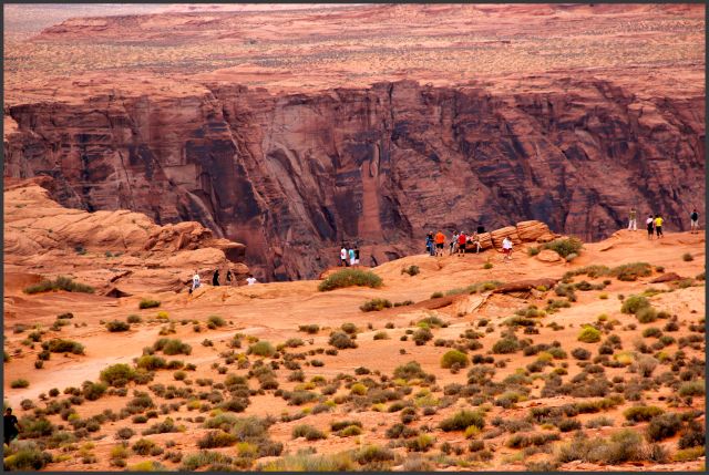
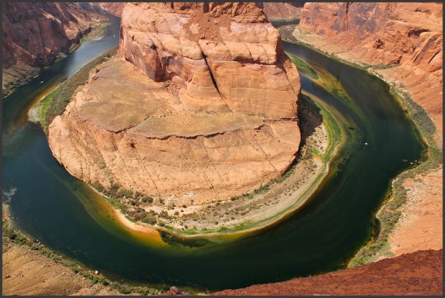
So what is the big attraction? The Colorado River winds its way through Glen Canyon and at this point  makes a perfect horseshoe shape. The water, having left the dam just a few miles upstream, is still crystal clear.

HB
The craggy canyon walls are beautiful and contrast nicely with the river below.

Although there were several groups of people visiting Horseshoe Bend Overlook while we were there, it didn't seem crowded. In fact, it's easy to get lost in the immenseness of it all. The river was 1000 feet below us. We could see for miles and miles to the horizon. It was impossible not to see the hand of God at work.

HB - R&K collage
It's the kind of place where you can get lost in your thoughts.

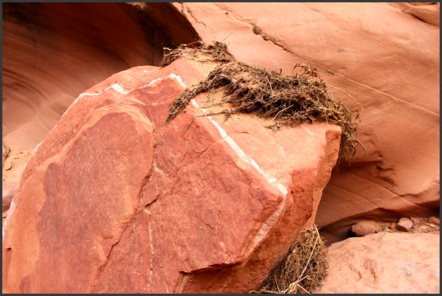
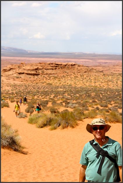
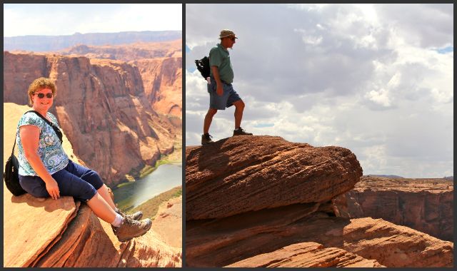
In the photo above with Richard standing on a rock, it's easy to see the diagonal striped layers which are remnants of the layers the ancient sand dunes had before they petrified into stone. Calcite (or limestone)  mixed in with rain and snow to cement the grains of sand together. It took a long time but finally all the sand dunes were petrified retaining their beautiful sloping dune shapes - what we call Navajo Sandstone.

Now, as the grains of sand erode, chunks of calcite remain. Some of these calcite chunks are covered with hard sandy bumps which are concretions of iron. As the grains of sand erode, the iron concretions are visible.

HB - popcorn rock
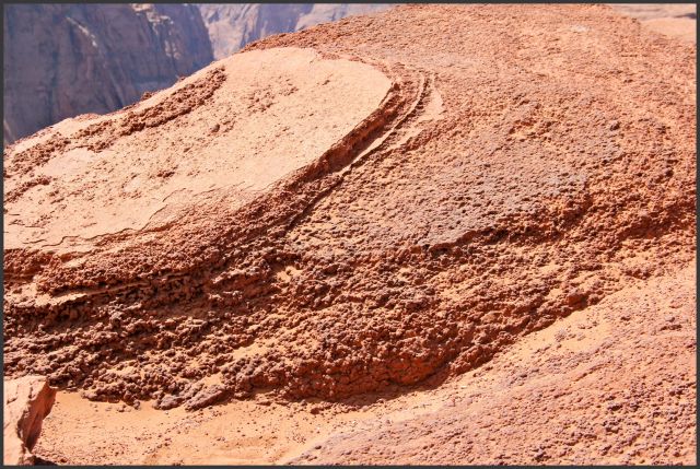
When the little concretion balls break loose, they are known as "Moki Marbles."

I noticed a lot of people speaking French, German and even Italian. Those I didn't overhear, I initiated a conversation with. In my informal survey, out of 75 people, only 4 were native English speakers! Perhaps we were there on International Visitor Day. Or perhaps Americans haven't discovered this gem yet - or don't want to make the trek. Whatever the reason, we enjoyed talking with several groups of visitors as we shared our state with them. A common query was why Arizona doesn't observe daylight savings time!

HB - on top of the world
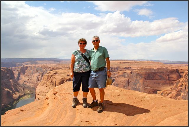
After taking a photo for one couple, we asked them to take ours - international relationship building!

It was a warm afternoon and the hike back seemed like it was ten times longer - probably because more of it was uphill. Just when I thought I couldn't go another step, a light rain began to fall cooling everything (including me!) down. God gives us exactly what we need, just when we need it. The remainder of the hike seemed to go faster and soon we were back at our car. As I downed yet another bottle of water, I marveled at the uniqueness of each of the canyons - like fingerprints, no two exactly alike. 

Thumb Up or Down: UUUUUUPPPPP!!!! Loved all three - but if I had to choose between Antelope Canyon and                                                    Secret Canyon, I would take Secret Canyon.
Miles Round Trip: see next post
Miles To Date: see next post
Percent of List Completed: 82%
Date of This Trip: August 30 - September 3, 2012


Saturday, October 6

87 and 74/100... Northern Arizona, part 1 - ROCKS

One of the most interesting and fun things about living in Arizona is that by traveling just an hour or two, both the climate and geological features can drastically change. While it's true there is no ocean beach, there is something for just about everybody. About a month ago we headed north to check out some awesome geological forms and get a break from the heat.

Leaving the sweltering Valley heat behind us, we arrived two and half hours later in Flagstaff where the temperature was in the high 60's and the sky was overcast. What a sweet respite! We soon found our first geological formation, Humphreys Peak (#87 on my "100 Things to See in Arizona" list).

Humphrey's Peak
Humphreys Peak is the highest natural point in Arizona with an elevation of 12,637 feet. It is the 153rd highest mountain peak in North America. Number one is Mount McKinley in Alaska (20,320 feet).

Humphreys Peak is part of the San Francisco Peaks. A very long time ago the San Francisco Peaks were joined together in one huge volcanic mountain. Eventually the volcano erupted blowing off the top of the mountain and leaving a ring of peaks which we see today. We could easily see this from Sunset Crater.

San Francisco Peaks - ed
Humphreys Peak looks "short" only because it is so far away. Agassiz Peak, the second highest at 12, 356 feet, is often mistaken for Humphreys Peak. While I have seen the San Francisco Peaks many times, I was never quite sure which one was Humphreys Peak - until now.

And turning 180 degrees around, we saw Sunset Crater!

Sunset Crater
Sunset Crater was not on my "100 Things" list because I have explored it several times in the past; it is well-worth the trip!

We contemplated hiking to the peak of Humphreys Peak... briefly. It is about a four and a half mile trek with a 3,333 foot elevation gain to the summit. The trail is rocky and narrow at the summit which has caused more than a few hiker's demise. Winds at the top can, and often are, over 50 miles per hour. Lightning strikes are frequent. Weather changes in a heartbeat. Park rangers told us only serious, well-prepared hikers should attempt it - and many don't make it to the summit the first time due to weather or altitude sickness. That was enough to convince us to enjoy it from afar!

Me and my peak
I was happy just to finally figure out which one was Humphreys Peak. 

After lunch, we drove another hour and a half north and the forested mountains gave way to a sandy, high desert terrain. Our destination was Page at the edge of Lake Powell. There are several places in the vicinity we wanted to explore and Page was our home-away-from-home for a few days. Our hotel room overlooked the Vermillion Cliffs (#74) and I never tired of gazing at them!

sunrise on vermillion cliffs
From our balcony, shortly after sunRISE, the cliffs were lit up like they were on fire. 

The Vermillion Cliffs are actually one layer, or step, of a much larger geological feature called the Grand Staircase of the Colorado Plateau in northern Arizona and southern Utah. These escarpments extend north from the Grand Canyon and are named for their color (Chocolate Cliffs, Vermillion Cliffs, White Cliffs, Gray Cliffs and Pink Cliffs). The sandstone rock is rich in minerals which gives each step its unique coloring. The Vermillion Cliffs, for example, get their vibrant color from the iron oxide in the sandstone.

We wanted to watch the color changes on the west side of the Vermillion Cliffs as the sun went down. It rained every afternoon we were in Page but we hoped it would be clear enough on the afternoon we set out to tour the Vermillion Cliffs that it would be a pretty sunset. We headed out US-89, turned onto US-89A and the rain began. After an intense but short rain shower, we were treated to the stunning beauty of the cliffs.

vermillion cliffs #1
The cliffs rise 1500 feet; to describe them as "impressive" is an understatement!

The scenery looked like it came straight out of a western movie. It wasn't difficult to imagine the bad guys in their black Stetsons, with their horses tethered to a tree, splitting up the loot from the train robbery in one of the small canyons at the foot of the cliffs.

vermillion cliffs #2
As the rain clouds moved off and the sky cleared, the cliffs took on a reddish hue.

We turned off on a dirt road to watch the sunset. We were there for about an hour and didn't see another car. It was quiet - just the chirping of birds and grasshoppers broke the silence. The air smelled clean and sweet from the recent rain and a slight breeze cooled the air. 

vermillion cliffs collage #1
This stretch of the Vermillion Cliffs is about ten miles long.

I set up my camera and began taking photos every 15 to 30 seconds. There wasn't much difference comparing one photo to the one immediately after it - but the difference was huge when comparing one photo to one 50 frames later. Change occurred so slowly it almost appeared not to change at all. Until it had.

Vermillion Cliffs Panoramic collage
The Vermillion Cliffs in glorious technicolor!

The cliffs changed color several times as the sun dipped lower and then disappeared beyond the horizon and again as sunlight was reflected off the clouds. Just when we thought the show was over, they would light up again.

road
Our dirt road stretched on for miles and miles.

vermillion cliffs #3
"There is no way in which a man can earn a star or deserve a sunset." G.K. Chesterton

As we watched the last bits of color fade away, we concluded it had been a very good sunset and a perfect end to our day.

Thumb Up or Down: UP!
Miles Round Trip: see next post
Miles to Date: see next post
Percent of List Completed: 80%
Date of This Trip: August 30 - September 3, 2012